Sunday, March 27, 2011

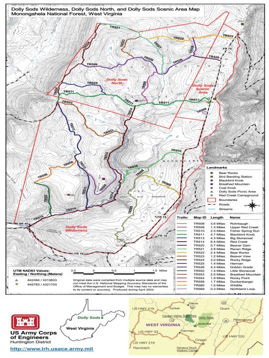
Dolly Sods Wilderness - Lion's Head Loop

To date I have entered nothing but Rocky Mountain hikes. Now it is time to add a few that are near and dear to my heart - Almost Heaven West Virginia.

We have several designated wilderness areas in West Virginia and this is (probably) the most popular to hikers, due to the close proximity to Washington DC.


On this day I would show a young engineer from Salt Lake City why we call it "Almost Heaven". He had transferred to West Virginia the previous year but had yet to see what we really had to offer.

Our adventure would be an 8-mile loop, with a spur hike to the Lion's Head. The hike would begin at the Red Creek trailhead at Laneville, West Virginia.


The first leg of the hike (TR514) would be a short, flat two mile hike along Red Creek to the junction of Big Stonecoal trail (TR513). At this junction you make your first stream crossing of Red Creek, usually by July/August the water is low enough to rock hop. Your other choices are to shed your shoes or waterproof hikers and a spare pair of socks. I chose option #3, I wore my wading shoes.


Big Stonecoal trail may not be immediately evident once you cross Red Creek but you can't miss the 4' cairn.


Big Stonecoal trail is an uphill mile to the junction of Rocky Point trail (TR554). According to a reference book I use (Waterfalls of Virginia and West Virginia), there are some very nice waterfalls on a spur trail just before the junction of Rocky Point trail.

I missed the small cairn that marked this spur and at the junction of Rocky Point we decided to bushwhack down to the stream. This sounds fairly straight-forward but I couldn't find a clear route to the bottom. Through the thick rhododendron I couldn't see terra firma.

We finally made it to Big Stonecoal Creek and a nice section of waterfalls. The blooming rhododendron made for even better photos.


As we moved downstream to more cascades I realized why I couldn't see through the thick rhododendron above - that's because there was no ground, it was a 20' cliff. I'm glad I didn't try to push through.


We pushed further downstream to a couple more cascades. The water appears dark, or tea-colored, due to the highly acidic tannic acid content from the conifers and bogs in the extreme headwaters.


From here we decided to bushwhack back uphill to the trail. Once at the trail the small cairn which marked the spur was very evident, I don't know how I missed it.

A quick left on Rocky Point trail and we were looking for another cairn marking the spur trail to Lion's Head - I hoped I wouldn't miss this one.

This cairn was much more obvious and another left and a short, steep section of trail to a nice plateau of "planted" pines. I say planted because they appeared to be perfectly aligned.


Through the pines, you simply pick one of the doors through the trees to the Rocky Point outcropping. It was also easy to find Lion's Head - simply look for the crowd.

It's easy to see why they call it Lion's Head.


After a short break and lunch overlooking the Red Creek valley it was backtracking to Rocky Point trail. This trail would wrap around (below) the rocky point we had just visited and eventually meet back up with Red Creek trail.

Again, master of the obvious, it's easy to see why they call this trail rocky point. It is nearly two miles long with the majority of it being ankle-breaking cobble.


Once we re-joined Red Creek trail it was a quick half-mile downhill to another Red Creek crossing. Just like the previous crossing, it's rock hopping or getting wet.


After this crossing it is an easy, flat two miles back to the trailhead. Somewhere between this crossing and the first crossing there is, according to the waterfall reference book, another nice set of falls.

It was easy to find as we had a small creek crossing directly above it. The moss on this cascade added to the beauty.


The remainder of the hike was relatively uneventful, except for the flushing of a grouse that nearly caused a heart attack. I think my young partner was very impressed with what West Virginia and Dolly Sods had to offer - but his weekend adventure had just started.


He still had my favorite place in the state to visit, the Seneca Backcountry.

Chris

Sunday, March 20, 2011

Mt. Elbert - Northeast Route

At the end of my two week 2008 trip to Colorado I took a day to add another 14er to my list. The goal this time was Mt. Elbert (14,433 feet), the highest point in Colorado and the second highest in the lower 48. There are a couple of routes to Mt. Elbert summit and we chose, for distance and ease of access to the trailhead.

This is what the northeast ridge looks like just off the main road outside of Leadville....no big deal, right?


We set up camp at the trailhead (10,000 feet), with plans to hit the trail before sun-up.


When we woke we found temps in the low 30s and frost on the windshield of the vehicle. A quick cup of coffee and a granola we were first on the trail. To reduce weight I left the DSLR in the vehicle and carried only my small, palm-sized video camera.

It was just getting daylight when we hit tree-line and it was a short distance to the first of the (infamous) false summits. The view from the first false summit, looking north toward Mt. Massive - there was a small herd of elk over there somewhere.


I don't remember if there were three or four of the false summits, it didn't matter, it was a brutal hike. Another false summit!


4.5 miles and over 4,000 feet in elevation gain later and we were on the summit, but not until we met an unexpected traveler a couple hundred yards from the summit. From a distance, I recognized another WVU hat coming up the east ridge route. What a small world, 2,000 miles from home and we run into a fellow mountaineer near the summit of Mt. Elbert.

The summit benchmark:


#1 of Colorado's 14ers!


Gratuitous summit shot:


The views from the summit were amazing as we were surrounded by the other 14ers of the Sawatch Range.

Mt. Massive (14,421)


La Plata Peak (14,336)


To the west  - Elk Mountains and seven more 14ers


This would be my second 14er summit, with my first being Greys, and I would gladly do Greys twice before I do this route again! Hiking down, particularly below treeline, is when you realize just how steep the ascent was - good thing it was dark as we climbed through treeline.

This was my hiking/fishing partner's first 14er, I think he was glad it was over.


What a great way to finish up a great Colorado fishing adventure (6 salmonid species) with a very demanding physical challenge.

Chris


Saturday, February 5, 2011

Grays Peak - Colorado 14er

September 9, 2007....my 40th birthday!

As I mentioned in my previous entry (Timber Lake - RMNP), this was my wife's birthday present to me. The day before this hike I did a tune-up of 10+ miles to 11,000 feet. The night before this hike, my younger brother took me to a Colorado Rockies game (40th b-day present) where I got to see two first ballot hall of famers - Greg Maddux and Trevor Hoffman.


I had been to Colorado a few times before but I never wanted to give up fishing time to hike, and I really wanted to climb one of those 14,000 peaks that are scattered across the state. This was my opportunity and I had scouted out the peak for ease of the climb and proximity to Denver. I came up with Grays Peak.

The day started well before daylight when my younger brother and following a stop for coffee, beverages, and snacks we arrived at the trailhead just after sun-up. Everything I had read recommended a high clearance 4-wheel drive vehicle and that is what I rented. The road to he traihead was difficult but I had to agree that the 4-wheel drive was needed. Until I arrived at the trailhead and found a couple of nice luxury vehicles had beaten me up there. One was a very nice Mercedes and the other was a Lexus, they had to be quite the driver to not rip the bottom out of those nice cars.

Back to the trail, the trailhead sits a little over 11,000 feet and it is just over three miles to the summit. The 3,000 feet in elevation gain over the three miles is a little deceiving as the first two miles are relatively flat, in that you don't realize you are climbing.

I thought it would be great to have my younger brother accompany me on my trip and celebrate my 40th on the summit of my first 14er. Unfortunately, that wouldn't happen as after less than half a mile he was bent over sucking wind. I sent him back to Denver with guidelines to pick me back up in seven hours - I figured four up and three down.

Shortly after I sent my brother packing I caught my first glimpse of Grays Peak.


You would think it would be intimidating staring at the summit nearly the entire time, but it really wasn't. At about the 1.5 mile marker you get a good few of Gray's summit and the sister s14er summit, Torreys.


I know it's an optical illusion but Torreys summit still appears higher, but at 14,267 it is a mere three feet shorter than Gray's 14,270.

Once you go around the right side of that small knob the climb gets a bit more interesting. At this point you hit a short section of steps, but these aren't ordinary steps, they were about three feet each step. That might seem too bad, but a 100 yard section of three-foot step ups at nearly 12,500 feet in elevation really zapped me. From this point on my pace slowed significantly!

Shortly after this section the trail splits with the trail to Torreys summit and it marks the beginning of the switchbacks. When I felt myself slowing to a crawl, I stopped at one of the switchbacks to see how far I had already come. You can see the well-worn trail on the left of this photo.


I had gone too far to turn back now, so onward and upward.

From the distance of the high valley floor it didn't appear that steep. When you get on the switchbacks you see that was also an illusion. Once I hit about the 13,500 mark I found myself stopping at nearly every switchback. Again, looking back down the trail I had travelled too far to stop now. You can also see how steep it is near the top. Look at the two groups of hikers below (one you can barely see near the bottom of the switchbacks).


At this point I was nearly on the summit and with that in view my pace picked up again until I made it to my destination. What a way to celebrate a 40th birthday!


I rested for a bit but I couldn't just sit there, the views were absolutely amazing!

Looking north at Torrey's summit:


Just to the west of Torreys was this crystal blue body of water - I wonder what swims in there?!


Looking to the southwest, I found myself looking down to the clouds.


Looking due west toward the Breckenridge area:


I also took this video, a 360-degree view from the summit:


After taking it all in, I had a decision to make; drop down into the saddle and knock Torrey's summit out too or take one summit and call it a say. I think I was more mentally drained than physically and I opted for calling it a day.

The hike down was non-eventful and within a couple of hours I found myself resting under a small pine tree at the trailhead - two hours ahead of schedule! I felt quite satisfied as I lay in wait of my younger brother and his shuttle service. Some of my thoughts: I ran cross-country and track (distance) from junior high through college, completed three half-marathons and I don't think I had ever done something so physically and mentally demanding....or maybe I was just old and out of shape.

Chris

Wednesday, February 2, 2011

Timber Lake Trail - Rocky Mountain National Park

The first time I made this trek was on a weekend trip to Colorado for my 40th birthday. For my 40th birthday my wife bought me an airline ticket so I could climb my first 14er on my 40th birthday. My birthday fell on a Sunday so to acclimate I made this hike up and around Timber Lake, stopping on the way back to pick up a few Colorado River cutts from Timber Creek.


You would think the trailhead would be somewhere near Timber Creek or Timber Creek campground, but instead it is across Trail Ridge Road from the Colorado River trailhead - about a mile up the road from the campground.

The trailhead sits somewhere around the 9,000 feet mark and Timber Lake rests in a cirque just over 11,000 feet. That's a pretty moderate elevation gain over the 5.3 miles, with only one strenuous section of trail.

The first mile or so of the trail is relatively flat as parallel the road. After you cross the footbridge on Beaver Creek the trail begins to quickly gain elevation. During this section of the trail you have excellent views of the Never Summer Mountain as you catch vistas in and out of the tree tops. I had several photos of these views but a lost laptop hard drive = lost pictures.

Once the trail turns east and heads away from the road the trail flattens out again until you reach the 3.5 mile mark and the junction with Long Meadows trail. This is also the first opportunity on this hike to wet a line for Colorado River cutthroat.

If you decide to remain on the trail your next half-mile is the most difficult section of the trail. With multiple switchbacks this section of the trail is still difficult until you reach the meadow section and Jackstraw back country campsite. Once you enter the high meadow you will also pick up Timber Creek again.


I think this is one of my favorite sections of water to fish anywhere in the park. The stream is a little over a foot wide, and deeper than wider, but if you can get a fly on the water through the high grasses the little cutts are very anxious to take anything that hits the water.

The final pitch up to the lake is another steep section of trail, but very short. The lake sits in the shadows of Mt. Ida at just over 11,000 feet.


When I visited this lake in September of 2007 the lake ha apparently turned over and had gone from (a reported) crystal blue to a dull shade of green...but still an amazing view!


The only fish I saw in the lake was a "floater". There are a couple of smaller lakes that surround Timber Lake but I saw no fish cruising those either and (again) lost hard drive = lost photos.

I have since made this hike one more time (August 2008) but instead of taking the difficult switchback section I made my way to the meadow by staying in Timber Creek and I stopped just short of the lake itself.

Chris

Sunday, January 23, 2011

Green Mountain Trail - Rocky Mountain National Park

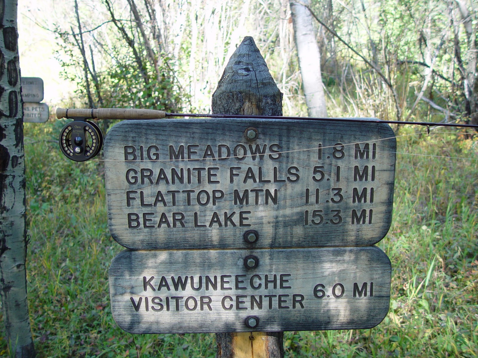
This is another of my favorite trails in Rocky Mountain National Park and another I have yet to complete. I've hiked this trail on three occasions but I've only completed the Granite Falls loop, over 10 miles round trip. The other trips were only as far as Big Meadows in search of the outstanding brook trout population.

As with most trail heads in RMNP this one is also over 8,000 feet; at almost 8,800 feet. Also, with these hikes at altitude make sure you hydrate very well to avoid altitude sickness. The trail head is located just inside the Kawuneeche entrance on the west side of RMNP.


The first 1.8 miles to Big Meadows in modestly steep. My younger brother has done this with me twice and Roaring River twice and his opinion is this hike is much worse. I disagree, my opinion is the first half-mile of the Lawn Lake trail is much worse. Regardless of opinion, it's about 600 feet of elevation gain in under two miles.

You never know what type of animals you're going to see during the climb to Big Meadows. I've seen both elk and moose in this area and the constant chatter of the squirrels are sometimes annoying. I ran into this cow and calf moose during an August 2008 hike.


The Big Meadows are a mile-long high meadow, with Tonahutu Creek meandering through it. These photos were taken during my first hike on Green Mountain trail in September, 2006.


Since then the bark beetles have decimated the canopy and well over 50% of the trees on the west side of the park are dead. Nature will recover as it always does, but I would watch for falling timber if the winds pick up.

Once you reach first sight of the meadows, the trail will circle the meadow as you travel the next 3.3 miles on the way to Granite Falls. The trail also levels out at this point as you gain just over 400 feet in elevation over that distance.

As you pass the upper end of Big Meadows, you pick up Tonahutu Creek which you will follow the remainder of the trek to Granite Falls.


This section of the trail is relatively flat but uneven in places. On a solo hike I went down about 3 miles in when I stepped on a root and twisted an ankle. I have bad ankles from many miles of running and many sprains playing basketball when I was younger. My ankle locked out, so (from my back) I popped it back in place and kept on trucking.

The next landmark on the trail is Granite Falls. I'm not sure of the height of Granite Falls but these cascades are impressive.


From Granite Falls it's another 2+ miles to Haynach Lakes or 5 miles back to the trail head. I plan to make the remaining journey to Haynach later this year when I visit again in August.

Granite Falls is a great day hike but prepare for the altitude and once you've beat that first 2 miles, you've got it made. If you go, pack a rod, Tonahutu Creek is absolutely polluted with brook trout!

Chris


Jone's Hole Canyon - Utah

As I try to deal with a severe case of cabin fever, I thought what better way than to relive some of the hikes I have done in Search of Native Salmonids. Not all of my hikes over the past 8-9 years have been in search of native fish, some were just in search of solitude or personal accomplishment.

I will try to recount these hikes in chronological order and this hike was completed on my first trip to the Rocky Mountains in September 2002.

We thought we would hike the canyon trail to the mouth of Jone's Hole Creek and the Green River. The idea was to fish the Green for a short period then Jone's Hole on the way out.

The trail head is located at the Jone's Hole Fish Hatchery about 20 miles outside of Vernal, Utah. The trail itself is four miles, through the canyon, to the Green River with very little elevation gain/loss.

This is the view dropping down into the canyon with the fish hatchery in the distance:


The canyon is narrow in places with the widest point in the four mile stretch still probably less than 1/4 mile wide. About a mile into the hike you have the opportunity to see what makes this area special - the history.


The canyon is also home to a small population of bighorn sheep. I'm pretty sure these are of the Rocky Mountain sub-species and not the desert sub-species. Regardless, we were lucky enough to see a group of juveniles and ewes.


It is a pleasant hike through the canyon but even in mid-September it was hot. I would recommend plenty of water or a water filter.

As you near the end of the canyon, you can see it open into the Green River canyon:


When we arrived at the Green River it was running chocolate milk. However, the small band of clear water where Jone's Hole dumped in contained brown trout that were easily over two feet in length! Easily the biggest trout I had ever seen at the time.

Those big boys didn't want anything I had to offer, so back up Jone's Hole we went. That wasn't too bad of a decision as Jone's Hole also contained some nice fish - particularly considering you can almost jump across it in most places. My fishing partner fought this bulldog for what seemed like five minutes in a pool not much bigger than a full-size truck bed.


For ease of the hike and the size of the fish, I would highly recommend this trek if you ever find yourself in eastern Utah and Dinosaur National Monument.

Chris