To date I have entered nothing but Rocky Mountain hikes. Now it is time to add a few that are near and dear to my heart - Almost Heaven West Virginia.
We have several designated wilderness areas in West Virginia and this is (probably) the most popular to hikers, due to the close proximity to Washington DC.


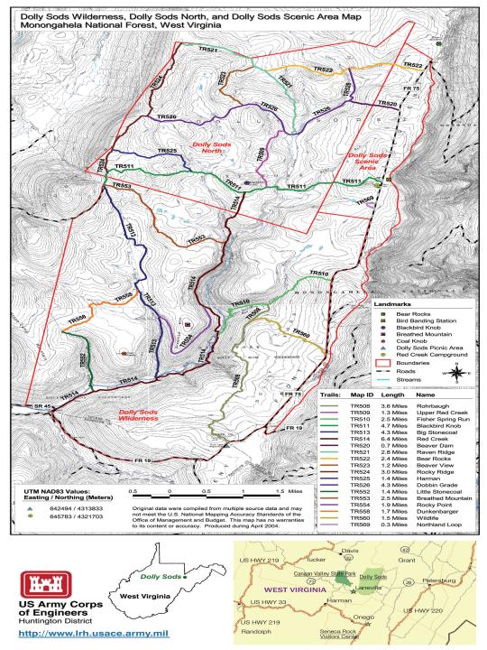
The first leg of the hike (TR514) would be a short, flat two mile hike along Red Creek to the junction of Big Stonecoal trail (TR513). At this junction you make your first stream crossing of Red Creek, usually by July/August the water is low enough to rock hop. Your other choices are to shed your shoes or waterproof hikers and a spare pair of socks. I chose option #3, I wore my wading shoes.


Big Stonecoal trail is an uphill mile to the junction of Rocky Point trail (TR554). According to a reference book I use (Waterfalls of Virginia and West Virginia), there are some very nice waterfalls on a spur trail just before the junction of Rocky Point trail.
I missed the small cairn that marked this spur and at the junction of Rocky Point we decided to bushwhack down to the stream. This sounds fairly straight-forward but I couldn't find a clear route to the bottom. Through the thick rhododendron I couldn't see terra firma.
We finally made it to Big Stonecoal Creek and a nice section of waterfalls. The blooming rhododendron made for even better photos.


We pushed further downstream to a couple more cascades. The water appears dark, or tea-colored, due to the highly acidic tannic acid content from the conifers and bogs in the extreme headwaters.


Through the pines, you simply pick one of the doors through the trees to the Rocky Point outcropping. It was also easy to find Lion's Head - simply look for the crowd.
It's easy to see why they call it Lion's Head.


Once we re-joined Red Creek trail it was a quick half-mile downhill to another Red Creek crossing. Just like the previous crossing, it's rock hopping or getting wet.

After this crossing it is an easy, flat two miles back to the trailhead. Somewhere between this crossing and the first crossing there is, according to the waterfall reference book, another nice set of falls.
It was easy to find as we had a small creek crossing directly above it. The moss on this cascade added to the beauty.


He still had my favorite place in the state to visit, the Seneca Backcountry.
Chris
We have several designated wilderness areas in West Virginia and this is (probably) the most popular to hikers, due to the close proximity to Washington DC.
On this day I would show a young engineer from Salt Lake City why we call it "Almost Heaven". He had transferred to West Virginia the previous year but had yet to see what we really had to offer.
Our adventure would be an 8-mile loop, with a spur hike to the Lion's Head. The hike would begin at the Red Creek trailhead at Laneville, West Virginia.

The first leg of the hike (TR514) would be a short, flat two mile hike along Red Creek to the junction of Big Stonecoal trail (TR513). At this junction you make your first stream crossing of Red Creek, usually by July/August the water is low enough to rock hop. Your other choices are to shed your shoes or waterproof hikers and a spare pair of socks. I chose option #3, I wore my wading shoes.

Big Stonecoal trail may not be immediately evident once you cross Red Creek but you can't miss the 4' cairn.

Big Stonecoal trail is an uphill mile to the junction of Rocky Point trail (TR554). According to a reference book I use (Waterfalls of Virginia and West Virginia), there are some very nice waterfalls on a spur trail just before the junction of Rocky Point trail.
I missed the small cairn that marked this spur and at the junction of Rocky Point we decided to bushwhack down to the stream. This sounds fairly straight-forward but I couldn't find a clear route to the bottom. Through the thick rhododendron I couldn't see terra firma.
We finally made it to Big Stonecoal Creek and a nice section of waterfalls. The blooming rhododendron made for even better photos.

As we moved downstream to more cascades I realized why I couldn't see through the thick rhododendron above - that's because there was no ground, it was a 20' cliff. I'm glad I didn't try to push through.

We pushed further downstream to a couple more cascades. The water appears dark, or tea-colored, due to the highly acidic tannic acid content from the conifers and bogs in the extreme headwaters.


From here we decided to bushwhack back uphill to the trail. Once at the trail the small cairn which marked the spur was very evident, I don't know how I missed it.
A quick left on Rocky Point trail and we were looking for another cairn marking the spur trail to Lion's Head - I hoped I wouldn't miss this one.
This cairn was much more obvious and another left and a short, steep section of trail to a nice plateau of "planted" pines. I say planted because they appeared to be perfectly aligned.

Through the pines, you simply pick one of the doors through the trees to the Rocky Point outcropping. It was also easy to find Lion's Head - simply look for the crowd.
It's easy to see why they call it Lion's Head.

After a short break and lunch overlooking the Red Creek valley it was backtracking to Rocky Point trail. This trail would wrap around (below) the rocky point we had just visited and eventually meet back up with Red Creek trail.
Again, master of the obvious, it's easy to see why they call this trail rocky point. It is nearly two miles long with the majority of it being ankle-breaking cobble.

Once we re-joined Red Creek trail it was a quick half-mile downhill to another Red Creek crossing. Just like the previous crossing, it's rock hopping or getting wet.

After this crossing it is an easy, flat two miles back to the trailhead. Somewhere between this crossing and the first crossing there is, according to the waterfall reference book, another nice set of falls.
It was easy to find as we had a small creek crossing directly above it. The moss on this cascade added to the beauty.

The remainder of the hike was relatively uneventful, except for the flushing of a grouse that nearly caused a heart attack. I think my young partner was very impressed with what West Virginia and Dolly Sods had to offer - but his weekend adventure had just started.

He still had my favorite place in the state to visit, the Seneca Backcountry.
Chris
Great Pictures man. I am planning a trip to Dolly sods on May 26th. Since you live In WV I am wondering if you could answer some question. Is that a good date to go like is the weather warm enough? Even though my dad spent four years at Davis and Elkins he doesnt know anything about this place I am trying to go to the best places in the map and I would greatly appreciate it if you could let me know what trails have great things on it and what trail is Lions head on. Thanks mate
ReplyDeleteJohn,
DeleteYou will be fine the end of May. My favorite time is June/July time period when the rhododendron are blooming.
Lion's Head is a spur trail off Rocky Point trail, near the junction of Big Stonecoal.
Good luck,
Chris
I went to the Dolly Sods last year, but didn't really pay attention to any of the trail names or anything. I remember taking a detour on a trail that involved a nice climb. Once I got to the top there were a lot of pine trees. There was also a field and various campsites and rock furniture. It looks like the picture you posted of the Lion's Head Overlook, but I just want to make sure I get the location right as I plan another trip this year.
ReplyDelete"A quick left on Rocky Point trail and we were looking for another cairn marking the spur trail to Lion's Head - I hoped I wouldn't miss this one."
ReplyDeleteI see this was posted five years ago, but looking at the map, was it a right onto Rocky Point or a left? I'm using your trail details to plan my own hike with a few friends next week.
Thanks for all the great details and the photos!
If you are hiking Big Stonecoal trail from Red Creek trail, you would make a right on Rocky Point.
ReplyDelete