Back in 2009 I completed this hike twice in 30 days, once via the northern terminus of the North Fork Mountain trail, and the second via Landis trail. The destination was the same, Chimney Top and a natural 360 degree view.
The North Fork Mountain trail is the easier route to Chimney Top.

This trail has several switchbacks during the approximately 1.5 hike to the spur trail for Chimney Top. The Landis trail may be a shorter mile hike to the junction with North Fork Mountain trail, but it is nearly straight up (no switchbacks).
My first trip to Chimney Top was in mid-September and the leaves along the trail were just beginning to change, making for a beautiful hike - not that this trail needed color to make it incredible.

It seemed like it didn't take any time at all to hit the top. You will know when you get to the top when you start seeing spur trails to the many vistas along the "edge".
One of the first views from the top is a view directly above the cabins along the North Fork of the South Branch of the Potomac and Route 28 - everything looks so small.

You could spend an entire day checking out the multiple vista points but we had a specific destination we were in search of.
It may be only another quarter-mile to the spur trail we were looking for, but with all of those views, who cares. Simply look for a small cairn and a short trail that goes straight up. You may end up getting off trail as you climb and weave your way through the rhododendron, but as long as you continue straight up you'll end up in the right place.
When you break out into the open again you will be staring at a 10-15 foot rock wall and this will be your view to the south.


I just had to relax and take it all in.


Looking east toward the Smokehole section of the South Branch of the Potomac (and eye to eye to one of the soaring buzzards).


And, finally, looking west toward Dolly Sods and Mt. Storm.


From here you can wrap around the perch overlooking Chimney Top to another view of the formation.

Although not a good shot, it surprised me, but there are peregrine falcons in the area. This one flew about twenty feet directly over my head.

The North Fork Mountain trail is the easier route to Chimney Top.

This trail has several switchbacks during the approximately 1.5 hike to the spur trail for Chimney Top. The Landis trail may be a shorter mile hike to the junction with North Fork Mountain trail, but it is nearly straight up (no switchbacks).
My first trip to Chimney Top was in mid-September and the leaves along the trail were just beginning to change, making for a beautiful hike - not that this trail needed color to make it incredible.

It seemed like it didn't take any time at all to hit the top. You will know when you get to the top when you start seeing spur trails to the many vistas along the "edge".
One of the first views from the top is a view directly above the cabins along the North Fork of the South Branch of the Potomac and Route 28 - everything looks so small.

You could spend an entire day checking out the multiple vista points but we had a specific destination we were in search of.
It may be only another quarter-mile to the spur trail we were looking for, but with all of those views, who cares. Simply look for a small cairn and a short trail that goes straight up. You may end up getting off trail as you climb and weave your way through the rhododendron, but as long as you continue straight up you'll end up in the right place.
When you break out into the open again you will be staring at a 10-15 foot rock wall and this will be your view to the south.

A quick scramble up the wall, pull yourself up, and you have made it to one of the most beautiful destinations anywhere in West Virginia. This is not Chimney Top proper but without good rock climbing skills or nerves of steel, you won't get any closer.

From this point you are looking across the North Fork valley to Dolly Sods Wilderness...and Chimney Top.

I just had to relax and take it all in.

Not the best video quality, but did I mention the 360-degree view?
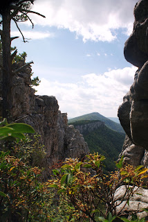
The video does not do this location justice but the photos do a little better job. Looking south along the spine of North Fork Mountain.

Looking east toward the Smokehole section of the South Branch of the Potomac (and eye to eye to one of the soaring buzzards).

Looking north toward Petersburg, West Virginia.

And, finally, looking west toward Dolly Sods and Mt. Storm.

If I would have brought sleeping gear, I could have spent days up there. Alas, all good things must come to an end and we scrambled down off our perch. Before we started our hike back down we did a little exploring of the rocky outcroppings.
You can go a short distance to the south, on the cobble between the main spine and the outcroppings of Chimney Top. Be careful though, that cobble is loose and I couldn't tell you where it goes after it drops out of sight.

From here you can wrap around the perch overlooking Chimney Top to another view of the formation.

Although not a good shot, it surprised me, but there are peregrine falcons in the area. This one flew about twenty feet directly over my head.

It was a quick, easy descent back to the trailhead. Bottom line to this trail: it is a short, moderately difficult, hike to one of the most beautiful locations you will find east of the Mississippi. If you plan this hike, take note there is not a source of water anywhere along the North Fork Mountain trail - plan accordingly.
Chris
No comments:
Post a Comment