Showing posts with label Colorado 14er. Show all posts

Sunday, December 11, 2011

DeCaLiBron - Colorado 14ers

This past August I added three more 14ers to my personal life list. The 7.25 mile loop would put me on top of three summits - the fourth (Mt. Bross) is currently closed.

The trailhead (12,000 feet) is located a few miles above Alma at Kite Lake, and it was crowded that early Sunday morning.


The first half-mile or so was a gradual climb but as you started through the scree to the saddle between Democrat and Cameron, the incline increased significantly. I love the early morning shadows of the Colorado Rockies - I stopped to look back toward the trailhead and I snapped this shot of the shadows.


It seemed like no time at all before I hit the first saddle and the view of the extreme headwaters of the South Platte was amazing.


After a quick stop at the saddle, it was a sharp left turn up Democrat's east slope. This is where the trail gets much steeper and there were several switchbacks to the false summit. It was a slow go between the saddle and the false summit but once to the top of the false summit the Democrat summit was in view. Even though I was hiking solo, I would not be alone on this trek.


A short distance later, I was standing on the summit of Mt. Democrat (14,148) - my third 14er.


I love the views from these summits. From the summit of Democrat I could see Mt. Elbert, which I summited in 2008 - I could not believe how much snow remained in August.


After a short rest on Democrat, it was back down to the saddle on my way to my next two summits. From the edge of the Democrat summit I could see my next two stops Cameron and Lincoln (in the background).


I always struggle on the downhill, it's hard on my old knees, but it was nice to get a breather before starting the climb to the Cameron summit. The climb up Cameron's ridge was not nearly as difficult as the Democrat climb and as the trail swung from the right side of the ridge to the left, I snapped this shot across the valley.


Then, looking back as the trail levels out before the Cameron summit.


From this point it was an easy hike to the large, flat summit of Cameron. I wasn't like a summit at all, more like a football field at 14,000 feet. I stopped only long enough to take a self-portrait on Cameron (14,238), the wind was howling to the point I was nearly blown down, time to find relief from the wind!


My next, and final, summit of the loop is Lincoln - a short distance from the Cameron summit.


After the climb up Democrat, then Cameron, the short trek to Lincoln was relatively easy. I say "relatively easy" because over 13,000 feet nothing is EASY. You can see the well-defined trail from near the Lincoln summit.


I didn't get a summit portrait on the small summit of Lincoln (sharp contrast to the size of Cameron's summit), but I did get a couple of other shots . Mt. Lincoln summit (14,286 feet) and 14er number five for me.


A much better shot to the north of the alpine lake and Quandary Peak.


After another quick summit stop, it was all downhill! The trail below the Cameron summit was very nice allowing me to make very good time on the way down.

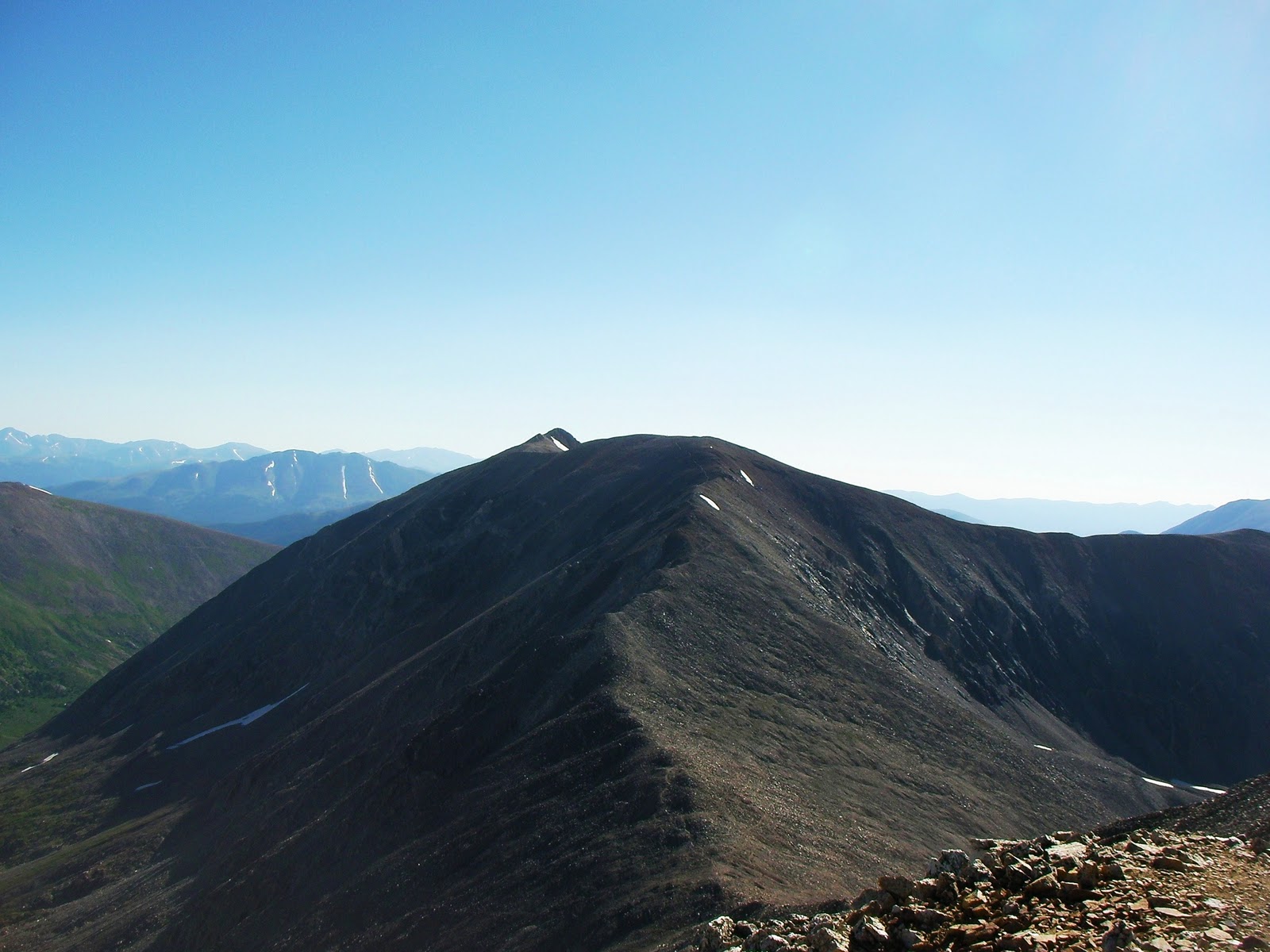
After passing below the Cameron summit I stopped the Cameron - Bross saddle to take a look back at where I had been earlier. From this saddle you can see the incline I climbed to get to the Democrat summit.


Then looking back at the large Cameron summit (left) and the small Lincoln summit (right)...


...then, finally, looking down at the Kite Lake trailhead.


If the summit for Mt. Bross was not on private property I could have added another 14er to my list.


I mentioned that downhill is hard on my old knees, well, I've never experienced downhill of this magnitude. Between the steepness of this downhill and the loose scree, this was quite a challenge.


I'm not sure what part of this loop was slower the climb of the final descent, but I made it down without falling.

The entire loop is just over seven miles with 3,700 feet of elevation gain and I made it back to the trailhead in under four hours.

 I enjoy taking time out of my fishing trips to knock these 14ers out...here's to my next summit!

Chris

Sunday, March 20, 2011

Mt. Elbert - Northeast Route

At the end of my two week 2008 trip to Colorado I took a day to add another 14er to my list. The goal this time was Mt. Elbert (14,433 feet), the highest point in Colorado and the second highest in the lower 48. There are a couple of routes to Mt. Elbert summit and we chose, for distance and ease of access to the trailhead.

This is what the northeast ridge looks like just off the main road outside of Leadville....no big deal, right?


We set up camp at the trailhead (10,000 feet), with plans to hit the trail before sun-up.


When we woke we found temps in the low 30s and frost on the windshield of the vehicle. A quick cup of coffee and a granola we were first on the trail. To reduce weight I left the DSLR in the vehicle and carried only my small, palm-sized video camera.

It was just getting daylight when we hit tree-line and it was a short distance to the first of the (infamous) false summits. The view from the first false summit, looking north toward Mt. Massive - there was a small herd of elk over there somewhere.


I don't remember if there were three or four of the false summits, it didn't matter, it was a brutal hike. Another false summit!


4.5 miles and over 4,000 feet in elevation gain later and we were on the summit, but not until we met an unexpected traveler a couple hundred yards from the summit. From a distance, I recognized another WVU hat coming up the east ridge route. What a small world, 2,000 miles from home and we run into a fellow mountaineer near the summit of Mt. Elbert.

The summit benchmark:


#1 of Colorado's 14ers!


Gratuitous summit shot:


The views from the summit were amazing as we were surrounded by the other 14ers of the Sawatch Range.

Mt. Massive (14,421)


La Plata Peak (14,336)


To the west  - Elk Mountains and seven more 14ers


This would be my second 14er summit, with my first being Greys, and I would gladly do Greys twice before I do this route again! Hiking down, particularly below treeline, is when you realize just how steep the ascent was - good thing it was dark as we climbed through treeline.

This was my hiking/fishing partner's first 14er, I think he was glad it was over.


What a great way to finish up a great Colorado fishing adventure (6 salmonid species) with a very demanding physical challenge.

Chris


Saturday, February 5, 2011

Grays Peak - Colorado 14er

September 9, 2007....my 40th birthday!

As I mentioned in my previous entry (Timber Lake - RMNP), this was my wife's birthday present to me. The day before this hike I did a tune-up of 10+ miles to 11,000 feet. The night before this hike, my younger brother took me to a Colorado Rockies game (40th b-day present) where I got to see two first ballot hall of famers - Greg Maddux and Trevor Hoffman.


I had been to Colorado a few times before but I never wanted to give up fishing time to hike, and I really wanted to climb one of those 14,000 peaks that are scattered across the state. This was my opportunity and I had scouted out the peak for ease of the climb and proximity to Denver. I came up with Grays Peak.

The day started well before daylight when my younger brother and following a stop for coffee, beverages, and snacks we arrived at the trailhead just after sun-up. Everything I had read recommended a high clearance 4-wheel drive vehicle and that is what I rented. The road to he traihead was difficult but I had to agree that the 4-wheel drive was needed. Until I arrived at the trailhead and found a couple of nice luxury vehicles had beaten me up there. One was a very nice Mercedes and the other was a Lexus, they had to be quite the driver to not rip the bottom out of those nice cars.

Back to the trail, the trailhead sits a little over 11,000 feet and it is just over three miles to the summit. The 3,000 feet in elevation gain over the three miles is a little deceiving as the first two miles are relatively flat, in that you don't realize you are climbing.

I thought it would be great to have my younger brother accompany me on my trip and celebrate my 40th on the summit of my first 14er. Unfortunately, that wouldn't happen as after less than half a mile he was bent over sucking wind. I sent him back to Denver with guidelines to pick me back up in seven hours - I figured four up and three down.

Shortly after I sent my brother packing I caught my first glimpse of Grays Peak.


You would think it would be intimidating staring at the summit nearly the entire time, but it really wasn't. At about the 1.5 mile marker you get a good few of Gray's summit and the sister s14er summit, Torreys.


I know it's an optical illusion but Torreys summit still appears higher, but at 14,267 it is a mere three feet shorter than Gray's 14,270.

Once you go around the right side of that small knob the climb gets a bit more interesting. At this point you hit a short section of steps, but these aren't ordinary steps, they were about three feet each step. That might seem too bad, but a 100 yard section of three-foot step ups at nearly 12,500 feet in elevation really zapped me. From this point on my pace slowed significantly!

Shortly after this section the trail splits with the trail to Torreys summit and it marks the beginning of the switchbacks. When I felt myself slowing to a crawl, I stopped at one of the switchbacks to see how far I had already come. You can see the well-worn trail on the left of this photo.


I had gone too far to turn back now, so onward and upward.

From the distance of the high valley floor it didn't appear that steep. When you get on the switchbacks you see that was also an illusion. Once I hit about the 13,500 mark I found myself stopping at nearly every switchback. Again, looking back down the trail I had travelled too far to stop now. You can also see how steep it is near the top. Look at the two groups of hikers below (one you can barely see near the bottom of the switchbacks).


At this point I was nearly on the summit and with that in view my pace picked up again until I made it to my destination. What a way to celebrate a 40th birthday!


I rested for a bit but I couldn't just sit there, the views were absolutely amazing!

Looking north at Torrey's summit:


Just to the west of Torreys was this crystal blue body of water - I wonder what swims in there?!


Looking to the southwest, I found myself looking down to the clouds.


Looking due west toward the Breckenridge area:


I also took this video, a 360-degree view from the summit:


After taking it all in, I had a decision to make; drop down into the saddle and knock Torrey's summit out too or take one summit and call it a say. I think I was more mentally drained than physically and I opted for calling it a day.

The hike down was non-eventful and within a couple of hours I found myself resting under a small pine tree at the trailhead - two hours ahead of schedule! I felt quite satisfied as I lay in wait of my younger brother and his shuttle service. Some of my thoughts: I ran cross-country and track (distance) from junior high through college, completed three half-marathons and I don't think I had ever done something so physically and mentally demanding....or maybe I was just old and out of shape.

Chris